
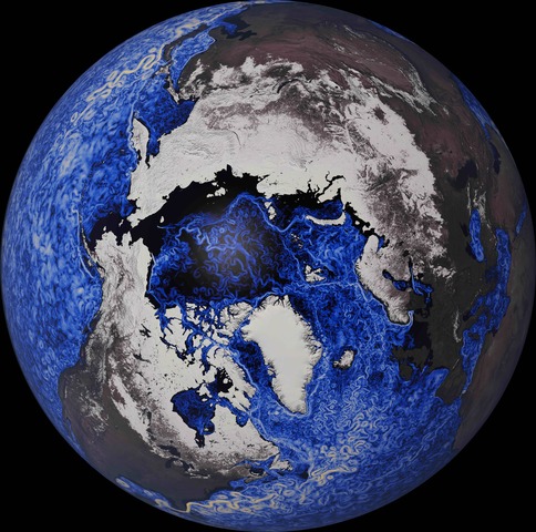
 Figure 1: Ocean Eddies and Snow Cover From 1.2 km ICON Simulation (from D. Klocke, MPI-M, DKRZ and NVIDIA)
The Digital Earths Lighthouse Activity supports the establishment of integrated interactive digital information systems that provide global and regional information on natural and human systems. ‘Digital Earth’ comes from the concept of a ‘Digital Twin’, an engineering term referring to a system where data feeds into a model of a system or object (e.g. a jet engine, a race car), and the object or system is modified as a result. In the case of ‘Digital Earths’, this is more than just Earth System Models (ESMs), but refers to bringing in data in new ways, and providing decision relevant predictions for human (not just natural) systems.
The Digital Earths (DE) Lighthouse Activity (LHA) was established in 2020, and has three main areas of activity. (1) Foster a global research network in km-scale modeling (horizontal resolution < 10km) of the Earth system and its individual components; (2) Establish an active community in the fusion of data with climate models both for data assimilation into climate models and the data driven modeling (e.g. Machine Learning/AI methods), expanding on existing numerical weather prediction and re-analysis efforts; and (3) Include human interactions on and impacts to human systems in ESMs to move beyond the physical earth system.
DE LHA helps encourage km-scale modeling, both regional and global. We have established a km-scale modeling group jointly with the Working Group on Numerical Experimentation (WGNE) under Earth System Modelling and Observation (ESMO), a WCRP Core Project. There is an active monthly webinar series.
There is also a separate group on spin ups of coupled models. Several different process teams have come together around critical issues. One of the most active is a Km-scale land group with a seminar series. A group on the organization of convection is under progress. These are joint groups with other WCRP Projects like GLASS (Land) and GASS (Convection).
Crucially, we are also seeking to build a regional-global alliance on km-scale modeling, by ensuring these groups above include both regional and global models, and team up with km-scale efforts under CORDEX.
As part of all these efforts, DE LHA is helping organize a Km-scale model ‘Pan Hackathon’ from May 12-18 2025. The hackathon will get centers around the world working on km-scale data at the same time, and share methods and workflows, as well as facilitate access to data.
Data and data-driven methods are a key component of digital earths. This has several components as the second thrust of the DE LHA. (1) Data and Assimilation for Digital Earths: Getting data into models (assimilation) and using emulator methods to compare to observations (simulators, the opposite of retrievals). We have sponsored and participated in several workshops on data assimilation for climate in 2022 and 2023. (2) Climate Model Emulators (especially km scale): Replacing model parameterizations or even entire component models with emulators and using emulators for different model tasks. (3) AI methods for Human-Earth System interaction: Using data driven methods as a way to better integrate human systems with models (linking with human system models, impact models, and local effects).
Finally, there is lots of exploration of interaction with human systems which is the third component of digital earths. This is evolving in several ways, but the landscape of human system interaction is very diverse, and is occurring on both global and regional levels. The foci for the DE LHA are water, energy and urban systems. There is an active group on Urban Digital Twins, with a collection of regional and finer scale modeling of coupled urban systems that is assisting with development of prototypes and data sets. It recently helped provide high resolution predictions for the Paris Olympics, and is starting to collaborate with the CORDEX Urban Flagship Pilot Study. Regional Hydroclimate Projects under GEWEX (including the new H2US RHP for the United States) are one of the interactions in the water space. Digital Earths LHA is also collaborating with the Earth Visualizations Engines (EVE) project to encourage linking km-scale models with human scale predictions.
Digital Earth systems are advancing to provide human scale predictions of the earth system. Km-scale models (regional and global) are becoming more common. To solve human system problems, ESMs are evolving to integrate with data in new ways, including data assimilation and using more data driven modeling where appropriate, to better use data and speed up modeling. This is evolving rapidly. Many efforts are also integrating human systems with km-scale modeling in new ways and the Digital Earth LHA activity is helping connect climate researchers around the word and WCRP projects to advance science.